

Real‑Time Photomapping: Powering Faster, Smarter Drone Data
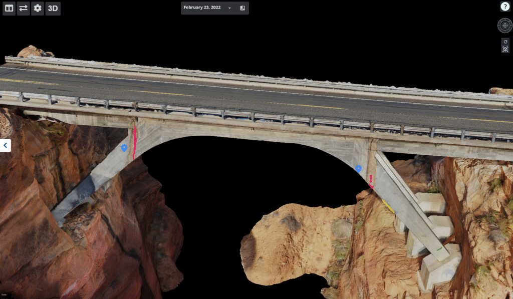
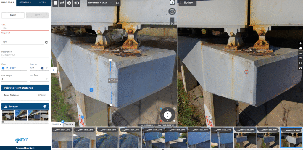
Photo Credit: gNext
Surveying infrastructure has always been an exercise in patience. Teams capture massive amounts of data – images, video, GPS coordinates – only to hit a bottleneck when trying to get it where it needs to go. The challenge isn’t just collecting the data; it’s transmitting it efficiently in environments where connectivity is unreliable or nonexistent.
LiveU is solving this problem head-on. Through a combination of real-time IP video streaming and LiveU File Transfer, public safety and transportation agencies can move critical survey data faster than ever before. Whether monitoring a bridge for structural weaknesses, assessing storm damage, or surveying a new work zone, LiveU ensures that the right people get the right data, at the right time.
Real-Time Situational Awareness with LiveU Video Streaming
Time-sensitive decisions require real-time information. With LiveU’s live video streaming, drone operators can send video directly to command centers, allowing engineers and safety officials to assess conditions as they unfold.
A DOT team monitoring an aging overpass, for example, doesn’t have to wait until the drone lands to review the footage. LiveU’s IP-based video transmission ensures that every frame is available for analysis immediately, no matter how remote the survey site. This capability is crucial in emergencies – such as assessing post-hurricane damage or monitoring active landslides – where time is of the essence.
The City of Westerville has also leveraged LiveU alongside their collaborative police and fire drone program for infrastructure and environmental monitoring. The technology has streamlined solar inspections and traffic studies, reducing the time required to conduct evaluations while keeping inspectors safe.
“We can feed the data through LiveU and watch that,” said Lieutenant Justin Alloway of the Westerville Division of Police.
By eliminating the need for inspectors to climb ladders or access hazardous rooftops, LiveU is helping municipalities improve efficiency while minimizing risk.
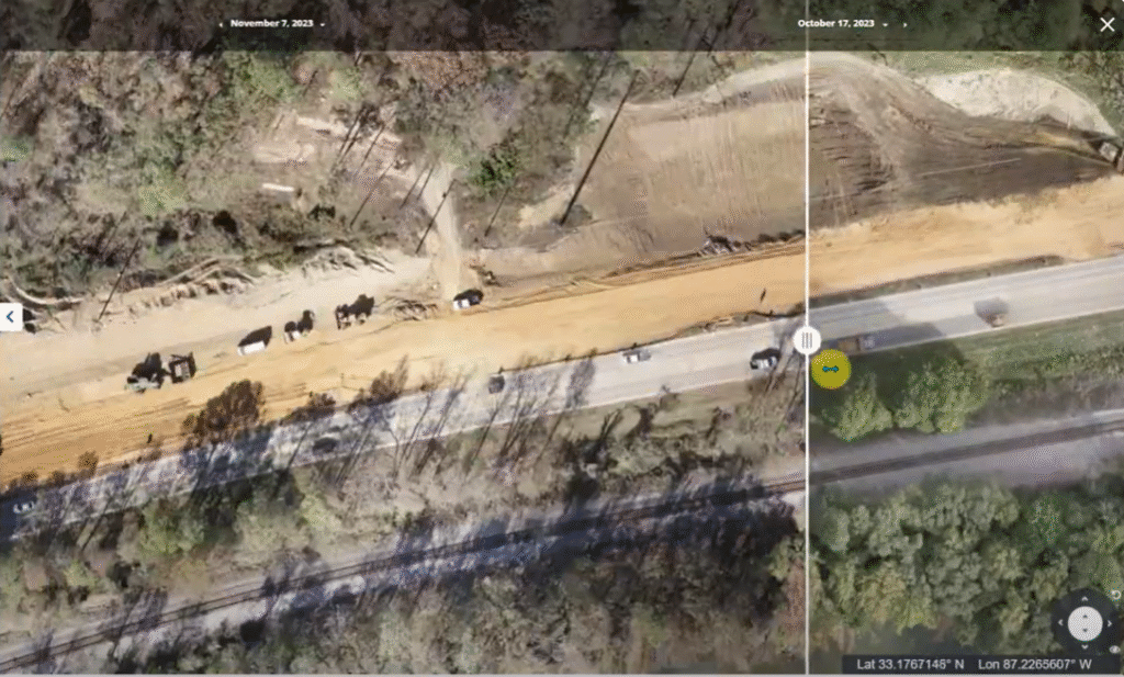
Alabama DOT Construction Corridor
Photo Credit: gNext
Eliminating Data Bottlenecks with LiveU File Transfer
But live video is only part of the equation. High-resolution photomapping and AI-driven analysis require massive amounts of raw data – high-res imagery, metadata, and GPS coordinates – all of which must be transferred quickly and securely. This is where LiveU File Transfer steps in.
Traditionally, survey teams relied on slow and unreliable hotel Wi-Fi, single-carrier hotspots, or worse – physically transporting SD cards back to headquarters. With LiveU File Transfer, those delays disappear.
Once a drone completes a survey, the SD card is inserted into a LiveU field encoder, which aggregates multiple network connections – cellular, satellite, Wi-Fi and even Mesh MANET nodes – to transmit gigabytes of data in record time.
The result? Instead of waiting days for high-resolution data to be processed, agencies can begin AI-powered photogrammetry analysis within hours. The current LiveU hardware already enables transfer speeds up to 100 Mbps, and the next-generation update will push that to 250 Mbps – roughly 1 GB per minute. That means a 50 GB dataset can be uploaded in under an hour, even from the field.
Bridge Inspection Depiction
Photo Credit: gNext
Connectivity Without Compromise: Carrier Diversity
One of the biggest challenges public safety teams face is unreliable connectivity. Most agencies are issued single-carrier hotspots, which work fine in cities but become useless in remote environments. If a drone captures mission-critical data in a rural area but can’t upload it until returning to an office, that delay could have serious consequences.
LiveU eliminates this issue with carrier diversity – a critical feature that allows LiveU field encoders to connect to multiple networks simultaneously. Whether it’s public, private or dedicated 1st-responder cellular networks, low earth-orbit satellite or other broadband options, LiveU dynamically prioritizes the best available connection. Even when survey teams are in transit, LiveU File Transfer can begin sending data the moment coverage is available, ensuring the process doesn’t wait until they’re back at headquarters.
Seamless Integration with Industry-Leading Platforms
LiveU isn’t just about speed – it’s about efficiency. The system integrates seamlessly with leading photogrammetry and video management platforms, including GNext, Pix4D, and Skydio. This means agencies can continue using their preferred tools while benefiting from faster data transmission and real-time connectivity.
For Skydio users, LiveU enables one-touch file transfers, ensuring that high-resolution data moves instantly from drone to analysis. And for agencies using multiple systems, LiveU’s flexible architecture ensures smooth interoperability, reducing friction and making adoption simple.
Smarter, Faster Public Safety Operations
Every moment matters in public safety and infrastructure management. The ability to see issues in real-time, transfer massive datasets in minutes, and operate in any environment without connectivity concerns is what sets LiveU apart. With LiveU File Transfer and real-time video streaming, agencies can move beyond the old limitations of survey workflows and operate with speed and confidence.
The future of public safety isn’t just about collecting data – it’s about moving it where it needs to go, faster than ever. LiveU makes that possible.
Learn how LiveU can transform your public safety and critical infrastructure workflows.