

Connecting the DOTs: Transforming Situational Awareness and Infrastructure Management
Summary
Introduction – Why is Real-Time Connectivity a Bottleneck for Modern DOTs?
Across the US, Departments of Transportation are being asked to do more with less. From monitoring thousands of miles of roadways to responding to emergencies and maintaining aging bridges and damaged roadways, the scale of modern infrastructure demands constant visibility and coordination. Yet many agencies are still relying on dated systems (limited cameras, radio communication, and manual field inspections etc.) that can’t keep up with today’s pace of change.
At the same time, expectations have never been higher. Decision-makers are under pressure to increase efficiency, improve safety, and deliver faster response times while managing shrinking budgets and a stretched workforce.
Nowhere is that pressure more visible than in America’s bridge network. Across the U.S., more than 617,000 bridges span rivers, highways, and railways. Forty-two percent are over 50 years old, well past their intended service life. Roughly 46,000 are structurally deficient according to CNN, and nearly 94,000 fail to meet current traffic or safety standards. These conditions introduce not only maintenance costs but serious risks: every delay in detection or lack of live visibility can have consequences for public safety and mobility. As these aging assets continue to serve millions of trips daily, the margin for error grows thinner.
The California Department of Transportation partnered with Skydio, Trimble, ESRI, San Diego Association of Governments (SANDAG), and the City of San Diego to deploy UAS Innovations for remote, autonomous infrastructure construction inspection. What the grant-funded study showed was that use of UAS technology proved to save time and money and provide better data to assist in administering infrastructure construction contracts compared to traditional inspection methods. They also found that UAS-enhanced projects have fewer worker injury claims. Read more about this study here.
How Can DOTs Move Large Inspection Files Faster?
This is one of the many areas where IP-video technology is reshaping what’s possible, giving DOT and public-safety teams real-time situational awareness from the field to the command center and enabling better decisions in less time. By honing a combination of bonded-cellular transmission with low-latency streaming and cloud-based or on-prem distribution, DOT agencies can get a live view of what’s happening across roadways, bridges, tunnels, and work zones -even in rural areas with limited connectivity.
According to Wheeler, successful UAS-enabled inspection depends on:
- Inspection-grade imagery aligned with NBIS requirements
- Secure transmission of large datasets
- Integration into bridge and asset management systems
- Interoperability across platforms
- Reliable performance in low-connectivity environments
“Moving this data quickly is essential to risk mitigation and timely maintenance decisions,” said Wheeler. “In disaster or post event scenarios, delays directly affect public safety, network resilience, and fiscal exposure. Closing the connectivity and interoperability gap elevates situational awareness from a reporting function into a real time executive decision support capability that strengthens asset stewardship and long-term infrastructure strategy.”
At the International Highway Engineering Exchange Program (IHEEP), it was apparent how these hurdles resonated among the DOT participants. Attendees from multiple state DOTs pointed to the same challenges: high data volumes, slow uploads, and a lack of interoperability across the many platforms and systems they rely on. “The recurring theme was pain points about disparate platforms and lack of compatibility. When you can serve as the connector between systems – agnostic to all of them – you deliver tremendous value.”
The demonstrated upload speeds – up to 1GB per minute – highlighted a clear operational advantage for agencies managing 100GB drone datasets. Accelerated file transfer and real-time streaming make an immediate impact. Instead of waiting hours to upload field data or video, agencies can begin analysis within minutes, dramatically improving the speed of inspections, repairs, and emergency response.
LiveU, a major player in live video, was described by one attendee as the “Swiss Army knife for transportation and infrastructure management.”
LiveU enables DOT operations through four core capabilities:
| Capability | What It Enables | Operational Impact for DOTs |
|---|---|---|
| FileBridge | Accelerated secure file transfer | Move large drone datasets in minutes instead of hours |
| VideoBridge | Real-time video transport | Immediate remote assessment of incidents |
| DataBridge | Internet connectivity at the edge | Connect sensors and devices in the field |
| RadioBridge | Integrated voice communication | Seamless voice communication integration across the LiveU ecosystem and unified communications across teams |
These four capabilities collectively address the spectrum of operational needs across DOTs, from live situational awareness to data management and communication.
With IP technology, agencies can securely transmit high-quality video from vehicles, drones, or inspection crews directly to central operations. This immediate visibility helps engineers evaluate incidents, monitor ongoing construction projects, and analyze potential hazards before they escalate. The same visibility empowers public-safety responders to understand what’s unfolding before arriving on scene, reducing uncertainty and improving coordination when seconds count.
Bonded IP transmission sends live aerial footage to command centers, mobile units and field devices, enabling a resilient, real-time common operating picture.
During bridge or pavement inspections, LiveU’s IP Pipe feature allows remote control of PTZ cameras, giving off-site experts full visibility without deploying additional staff. Video Return as a Service (VRaaS) enables two-way live collaboration between crews and command centers. When paired with drone programs, LiveU extends these capabilities into the air, streaming real-time aerial footage for faster assessment of accident scenes, roadway damage, or environmental impacts that could threaten public safety.
At IHEEP, these use cases weren’t theoretical. They matched exactly what DOT professionals said they struggle with daily. Massive drone-mapping files, incompatible software, and limited upload speeds slow down the critical flow of information between field and command. The ability to integrate seamlessly into any existing ecosystem and move high-volume data quickly made it clear that IP-video isn’t just for broadcasters.
This same architecture supports Drone as First Responder (DFR) workflows, enabling immediate video response in the moments before human crews can mobilize. Drones equipped with live video transmitters can deliver high-definition video directly to DOT and public-safety command centers within seconds, giving leaders situational intelligence to coordinate detours, manage incidents, and deploy resources more effectively.
Decision-makers can view multiple live sources simultaneously, analyze conditions, and upload datasets such as drone photogrammetry or inspection imagery for real-time AI-assisted analysis. The result: the gap between detection and decision narrows dramatically.
What DOTs Gain from Proactive, Video-Driven Infrastructure Management
Beyond visibility, agencies can reduce costs and operational strains with the help of IP video. By minimizing unnecessary site visits and enabling remote analysis, DOTs can conserve resources while extending the reach of their technical experts. Specialized engineers can now oversee multiple projects at once, regardless of location. For public-safety partners, that same capability translates into faster, more informed responses with fewer blind spots.
The IHEEP discussions also highlighted a broader mindset shift: DOTs are ready to experiment, collaborate, and adopt creative new approaches to infrastructure management. As one participant noted, “There’s a willingness to explore things very creatively. Everyone’s solving similar problems at different stages of technology adoption.”
DOTs in Florida, Alaska, Alabama, and beyond are already proving what’s possible – gaining a live operational picture across massive networks, improving interagency coordination, and setting a new standard for how public organizations use technology to protect citizens and assets.
FAQ: IP-Video for Transportation Infrastructure
What is situational awareness for DOTs?
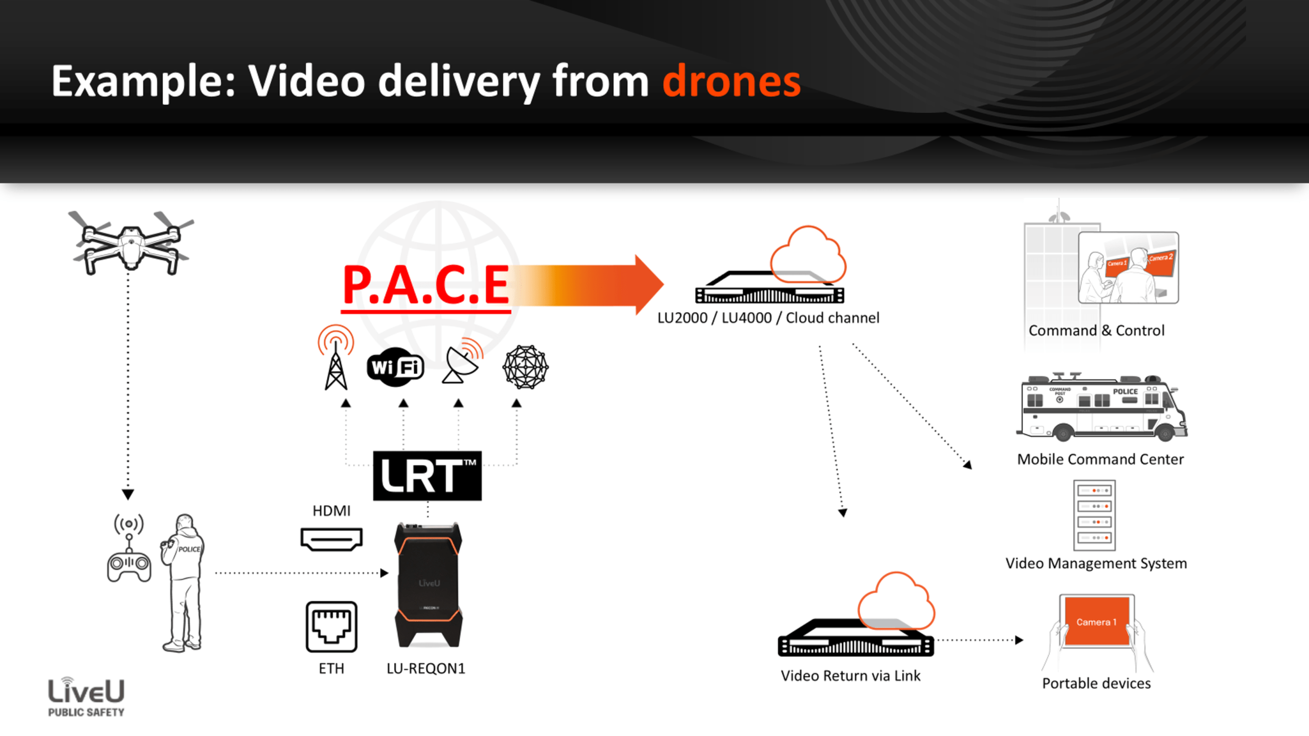
Situational awareness for DOTs involves creating a unified real-time visual intelligence layer across vast geographical areas. It moves beyond just having “cameras on a map “to having an active, low-latency stream of every critical asset. Having live, real-time visibility into roadway conditions, bridge status, and incident locations allow decision-makers to act within minutes rather than hours. LiveU achieves this through bonded cellular video transmission from drones and field cameras directly to command centers.
How do DOTs use drones in emergency response?
Drones serve as the “eyes in the sky,” particularly through Drone as First Responder (DFR) programs, which provide a perspective that ground units cannot. These drones aren’t just for looking, they are for collecting data. LiveU facilitates the transmission of thermal imagery for search and rescue or identifying “hot spots” in infrastructure (like overheating electrical components on transit lines). Drone as First Responder programs stream aerial footage to command centers before crews arrive.
LiveU technology enables drones to stream high-definition aerial footage directly to the command center over cellular networks. This allows incident commanders to evaluate the scale of a multi-vehicle pileup, forest fire encroachment on a highway, or structural damage after a natural disaster before crews even arrive on the scene.
Why is bonded connectivity important for infrastructure monitoring?
In infrastructure, connectivity is often the weakest link, especially in tunnels, rural corridors, or during mass-casualty events where local towers are congested. IP bonded technology helps maintain connectivity even in the most challenging signal environments. If one network fails or drops in quality, the system dynamically shifts the data load to the other available networks. This ensures that the video stream remains rock-solid and “mission-ready.”
LRT™ (LiveU Reliable Transport): is the “secret sauce.” Instead of relying on a single SIM card or a shaky Wi-Fi signal, LiveU’s patented bonding technology combines up to 14 different connections (5G/4G, Wi-Fi, and Satellite like Starlink) into one resilient data pipe. It ensures reliable live transmission even in rural or low-signal environments.
What types of data can LiveU transmit?
LiveU technology can transmit live video, drone imagery, inspection footage, and large photogrammetry datasets. LiveU FileBridge (LiveU File Transfer) capabilities allow it to act as a high-speed mobile broadband hub. This includes 4K/HD live video, drone imagery, and 10-bit HDR footage for high-detail inspections.
Field teams can transmit massive photogrammetry datasets and 3D scans (used for digital twins of bridges or roads) while they are still on-site. This eliminates the “SD card run,” where a technician has to drive back to a headquarters to upload data. With speeds up to 250 Mbps, the data moves from the field to the GIS or analysis platform instantly, shortening the time from “capture” to “actionable insight.”
Learn more about LiveU’s solutions for critical infrastructure and utilities.